


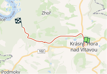

11.8 km | 14.8 km-effort
![Trail On foot Krásná Hora nad Vltavou - [Ž] U Slupné strouhy - Krásná Hora - Photo](https://media.geolcdn.com/t/1900/400/a05476e2-d42f-4e1a-8934-678ca86e1888.jpeg&format=pjpeg&maxdim=2)

Tous les sentiers balisés d’Europe GUIDE+


FREE GPS app for hiking
 SityTrail
IGN / Geographical institutes
SityTrail World
The world is yours!
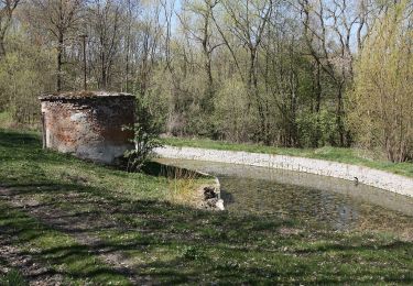
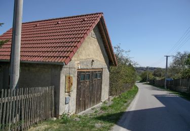
Trail On foot of 3.7 km to be discovered at Central Bohemia, Unknown, Krásná Hora nad Vltavou. This trail is proposed by SityTrail - itinéraires balisés pédestres.
Trail created by cz:KČT.
![Trail On foot Krásná Hora nad Vltavou - [Ž] U Slupné strouhy - Krásná Hora - Photo 1](https://media.geolcdn.com/t/2048/auto/0bd42ed4-dd92-46bf-909a-8bc4ac625785.jpeg&format=jpg&maxdim=0 "Trail On foot Krásná Hora nad Vltavou - [Ž] U Slupné strouhy - Krásná Hora - Photo 1")
![Trail On foot Krásná Hora nad Vltavou - [Ž] U Slupné strouhy - Krásná Hora - Photo 2](https://media.geolcdn.com/t/2048/auto/74284a43-3b02-4e15-9f82-c0f8ddf62798.jpeg&format=jpg&maxdim=0 "Trail On foot Krásná Hora nad Vltavou - [Ž] U Slupné strouhy - Krásná Hora - Photo 2")
![Trail On foot Krásná Hora nad Vltavou - [Ž] U Slupné strouhy - Krásná Hora - Photo 3](https://media.geolcdn.com/t/2048/auto/2f986194-fead-4814-ba94-c7d38cdec11c.jpeg&format=jpg&maxdim=0 "Trail On foot Krásná Hora nad Vltavou - [Ž] U Slupné strouhy - Krásná Hora - Photo 3")
![Trail On foot Krásná Hora nad Vltavou - [Ž] U Slupné strouhy - Krásná Hora - Photo 4](https://media.geolcdn.com/t/2048/auto/8fe7b69a-e81f-4594-97b7-d8efd65c7a09.jpeg&format=jpg&maxdim=0 "Trail On foot Krásná Hora nad Vltavou - [Ž] U Slupné strouhy - Krásná Hora - Photo 4")
![Trail On foot Krásná Hora nad Vltavou - [Ž] U Slupné strouhy - Krásná Hora - Photo 5](https://media.geolcdn.com/t/2048/auto/dae82cf1-999f-40fd-9d5f-26ce14aa4429.jpeg&format=jpg&maxdim=0 "Trail On foot Krásná Hora nad Vltavou - [Ž] U Slupné strouhy - Krásná Hora - Photo 5")
![Trail On foot Krásná Hora nad Vltavou - [Ž] U Slupné strouhy - Krásná Hora - Photo 6](https://media.geolcdn.com/t/2048/auto/696f27db-f760-4e63-a5fa-1a187191ff0f.jpeg&format=jpg&maxdim=0 "Trail On foot Krásná Hora nad Vltavou - [Ž] U Slupné strouhy - Krásná Hora - Photo 6")
![Trail On foot Krásná Hora nad Vltavou - [Ž] U Slupné strouhy - Krásná Hora - Photo 7](https://media.geolcdn.com/t/2048/auto/591b8a26-968d-45ff-8f29-d9c92faaa242.jpeg&format=jpg&maxdim=0 "Trail On foot Krásná Hora nad Vltavou - [Ž] U Slupné strouhy - Krásná Hora - Photo 7")
![Trail On foot Krásná Hora nad Vltavou - [Ž] U Slupné strouhy - Krásná Hora - Photo 8](https://media.geolcdn.com/t/2048/auto/f8b701df-df2b-4130-83ad-b3b76dd849e0.jpeg&format=jpg&maxdim=0 "Trail On foot Krásná Hora nad Vltavou - [Ž] U Slupné strouhy - Krásná Hora - Photo 8")
![Trail On foot Krásná Hora nad Vltavou - [Ž] U Slupné strouhy - Krásná Hora - Photo 9](https://media.geolcdn.com/t/2048/auto/a05476e2-d42f-4e1a-8934-678ca86e1888.jpeg&format=jpg&maxdim=0 "Trail On foot Krásná Hora nad Vltavou - [Ž] U Slupné strouhy - Krásná Hora - Photo 9")
![Trail On foot Milevsko - [Č] Milevsko - Jetětice - Photo](https://media.geolcdn.com/t/375/260/19b73443-10f3-4ee2-b906-2593e9794aea.jpeg&format=jpg&maxdim=2)
On foot
![Trail On foot Milevsko - [Ž] Budák rybník - Karlov - Photo](https://media.geolcdn.com/t/375/260/6a7dbc34-5b93-44a1-bcc9-52d789012a05.jpeg&format=jpg&maxdim=2)
On foot
![Trail On foot Sedlčany - [Ž] Sukova cesta - Photo](https://media.geolcdn.com/t/375/260/758ff4ec-b111-4e98-8809-03378f3f9591.jpeg&format=jpg&maxdim=2)
On foot
On foot
On foot
On foot
On foot
On foot